Berlin Tempelhof Airport (THF)
Orientation and Maps
(Berlin, Germany)
TEMPELHOF AIRPORT CLOSED ON 30TH OCTOBER 2008
Germany's glorious capital city, Berlin has a population of around 3.5 million and is also the country's largest city. With a host of attractions whatever the time of day, Berlin has gained quite a reputation in recent years. The city was transformed at the end of the 20th century, following the demise of the world-famous Berlin Wall, which once physically divided the city in two.
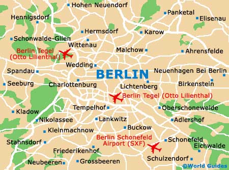
Berlin contains three airports, of which Berlin Tempelhof Airport (THF) is the closest, lying minutes to the south of the centre. Within the city you will find a reliable public transport network, which consists of buses, trams and electric trains, all of which are operated by the Berliner Verkehrsbetriebe (BVG) and the Deutsche Bahn (DB). The city is split into three main zones, A, B and C, which relate directly to tariffs applied on most transport.
Berlin Tempelhof Airport (THF) Maps: Important City Districts
Within Berlin, the heart of the city is based around the scenic Spree River, which winds its way around the city and joins the Spandau Lake to the west. There are currently eight main districts in Berlin, which include Charlottenburg, Prenzlauer Berg, Friedrichshain and Wilmersdorf.
Whilst the city is now as one, there are still two main city centres, located in the east and the west. CityEast stands around the Mitte region and along the Unter den Linden, while CityWest is sited near to the Zoo train station.
Germany Map

Berlin Map